Cape Hatteras
Cape Hatteras: a perilous bend in the Outer Banks.

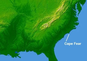
Cape Hatteras is a cape located at a pronounced bend in Hatteras Island, one of the barrier islands of North Carolina. It lies in the chain of the Outer Banks, which arch out into the Atlantic Ocean and back toward the mainland, creating lagoons and estuaries. The cape is the site where the two great basins of the East Coast meet. Its treacherous offshore waters are known as the Graveyard of the Atlantic, where over 600 ships have wrecked over the past 400 years. Cape Hatteras is also the nearest landmass on the North American mainland to Bermuda, about 563 nautical miles (648 mi; 1,043 km) to the east-southeast.
- Location
- Hatteras Island, Outer Banks, North Carolina
- Type
- Cape on a barrier island
- Climate
- Humid subtropical (Köppen: Cfa)
- Notable Feature
- Tallest lighthouse in the United States (Cape Hatteras Lighthouse, 198.48 ft)
- Known For
- Graveyard of the Atlantic; frequent hurricane strikes; Diamond Shoals
- Protected Area
- Cape Hatteras National Seashore
Verified Timeline
Lore & Background
The name Hatteras is the sixth oldest surviving English place-name in the U.S. An inlet north of the cape was named 'Hatrask' in 1585 by Sir Richard Grenville, admiral of the Roanoke Colony expedition. It was later applied to the island and cape, and modified to 'Hatteras.' Hatteras is also the name of the Hatteras Indians. The waters off Cape Hatteras are treacherous due to Diamond Shoals, a bank of shifting sand ridges hidden beneath the turbulent sea. Over 600 ships have wrecked here, victims of shallow shoals, storms, and war. As early as the 1870s, island villagers served in the United States Life-Saving Service, and others staffed lighthouses built to guide mariners. The first lighthouse at the cape was built in 1803; it was replaced by the current Cape Hatteras Lighthouse in 1870, which at 198.48 feet from the ground to the tip of its lightning rod is the tallest lighthouse in the United States. In 1999, the 4830-ton lighthouse was lifted and moved inland a distance of 2,900 feet (880 m) because the receding shoreline had come dangerously close.
Reader's Guide
Cape Hatteras holds enduring significance as a landmark of maritime danger and coastal resilience. Its position where two ocean basins meet, combined with the shifting Diamond Shoals, has made it a graveyard for over 600 ships over four centuries, shaping local lifesaving traditions and lighthouse construction. The Cape Hatteras Lighthouse, the tallest in the U.S., symbolizes the ongoing effort to guide mariners through these treacherous waters. The area is also a focal point for hurricane research and preparedness, being the highest-risk area for tropical storms along the U.S. eastern seaboard. Hurricane Isabel in 2003 was particularly devastating, splitting Hatteras Island between Frisco and Hatteras and washing out NC 12. The new inlet was filled in with sand by the Army Corps of Engineers in a process that took nearly two months. On September 6, 2019, Hurricane Dorian made landfall at Cape Hatteras. Today, Cape Hatteras National Seashore protects parts of three barrier islands: Bodie Island, Hatteras Island, and Ocracoke Island. The community of Buxton lies on the inland side of the Cape itself, at the widest part of Hatteras Island, and is the largest community on the island, home to governmental offices and schools.
Did You Know?
- Cape Hatteras is the nearest landmass on the North American mainland to Bermuda, which is about 563 nautical miles (648 mi; 1,043 km) to the east-southeast.
- The name Hatteras is the sixth oldest surviving English place-name in the U.S., originating from an inlet named 'Hatrask' in 1585 by Sir Richard Grenville.
- The Cape Hatteras Lighthouse, at 198.48 feet (60.50 m) from the ground to the tip of its lightning rod, is the tallest lighthouse in the United States.
- In 1999, the 4830-ton lighthouse was lifted and moved inland a distance of 2,900 feet (880 m) due to shoreline erosion.
- Hurricane Isabel in 2003 split Hatteras Island between Frisco and Hatteras, washing out NC 12 and requiring a two-month Army Corps of Engineers project to fill the new inlet.
The Graveyard of the Atlantic
The Outer Banks form a chain of barrier islands along North Carolina's coast. For centuries these islands channeled shipping traffic along favorable ocean currents, making the waters a natural highway for vessels. But just offshore at Cape Hatteras, Diamond Shoals, a bank of shifting sand ridges hidden beneath the turbulent sea, has never promised safe passage for ships. Over 600 ships wrecked here as victims of shallow shoals, storms, and war. In the past 400 years, the graveyard has claimed many lives, but island villagers saved many. As early as the 1870s, villagers served in the United States Life-Saving Service. Others staffed lighthouses built to guide mariners. Few ships wreck today, but storms still uncover the ruins of the old wrecks that lie along the beaches of the Outer Banks.
From Hamilton's Plea to the Tallest Brick Tower
The first lighthouse at the cape was built in 1803. It was replaced by the current Cape Hatteras Lighthouse in 1870, which at 198.48 feet (60.50 m) from the ground to the tip of its lightning rod is the tallest lighthouse in the United States and one of the tallest brick lighthouses in the world. In 1999, as the receding shoreline had come dangerously close to Cape Hatteras Lighthouse, the 4830-ton lighthouse was lifted and moved inland a distance of 2,900 feet (880 m). Its distance from the seashore is now 1,500 feet (460 m), about the same as when it was originally built.
The Sea's Slow Reclaim
The source does not provide details about the sea's gradual encroachment on the lighthouse or the fate of earlier beacons beyond what is stated in the lore and guide sections. The source states that in 1999, the lighthouse was moved inland because the receding shoreline had come dangerously close, and that its current distance from the seashore is 1,500 feet (460 m).
A Landmark of the National Seashore
Today the Cape Hatteras Light stands as the tallest lighthouse in the United States, measuring 198.48 feet (60.50 m) from the ground to the tip of its lightning rod. It anchors the Cape Hatteras National Seashore, which protects parts of three barrier islands: Bodie Island, Hatteras Island, and Ocracoke Island. Beach and sound access ramps, campgrounds, nature trails, and lighthouses can be found and explored on all three islands. The community of Buxton lies on the inland side of the Cape itself, at the widest part of Hatteras Island. It is the largest community on the island, and is home to the governmental offices and schools for the island.
More in Capes And Headlands 1-21
Spotted an error? Know more?
This is a living reference — every entry is fact-audited, and reader corrections feed straight into our audit queue. Suggest an edit · See this site's audit record