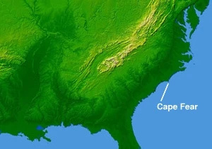
Cape Fear (headland)
Headland on North Carolina coast, site of historic landfalls and shipwrecks.

Cape Fear is a prominent headland jutting into the Atlantic Ocean from Bald Head Island on the coast of North Carolina in the Southeastern United States. It is largely formed of barrier beaches and the silty outwash of the Cape Fear River as it drains the southeast coast of North Carolina through an estuary south of Wilmington. Cape Fear is formed by the intersection of two sweeping arcs of shifting, low-lying beach, the result of longshore currents which also form the treacherous, shifting Frying Pan Shoals, part of the Graveyard of the Atlantic.
- location
- Bald Head Island, North Carolina, Southeastern United States
- type
- Headland
- named_by
- Sir Richard Grenville expedition (1585)
- first_recorded_landfall
- Giovanni da Verrazzano (1524)
- notable_feature
- Frying Pan Shoals, part of the Graveyard of the Atlantic
- ecological_zone
- Salt-tolerant grassland with sea oats and other grasses
Lore & Background
Cape Fear was the landing place of British General Sir Henry Clinton during the American Revolutionary War on May 3, 1775. The name comes from the 1585 expedition of Sir Richard Grenville. Sailing to Roanoke Island, his ship became embayed behind the cape. Some of the crew were afraid they would wreck, giving rise to the name Cape Fear. It is the fifth-oldest surviving English place name in the U.S. Giovanni da Verrazzano, the Italian explorer sailing for France, made landfall after crossing the Atlantic at or near Cape Fear on March 1, 1524. The Cape Fear estuary drains the largest watershed in North Carolina, containing 27% of the state's population. Cape Fear acts as a breakpoint for tropical cyclone warnings and watches issued by the National Hurricane Center.
Reader's Guide
Cape Fear is significant as a landmark of early European exploration and colonial history in North America. It marks the landfall of Giovanni da Verrazzano in 1524 and was the site of Sir Richard Grenville's 1585 expedition, which gave the cape its enduring name. During the American Revolutionary War, British General Sir Henry Clinton landed there in 1775. The headland's treacherous Frying Pan Shoals, formed by longshore currents, have made it a notorious part of the Graveyard of the Atlantic. Ecologically, its dunes and salt-tolerant grasslands support a unique coastal plant community. The cape also serves as a critical reference point for tropical cyclone warnings issued by the National Hurricane Center. Its name and geography have inspired multiple film and television adaptations, including the 1962 film Cape Fear, its 1991 remake, and a 2026 TV series.
Did You Know?
- Cape Fear is the fifth-oldest surviving English place name in the United States.
- The name originated from the 1585 expedition of Sir Richard Grenville, when crew members feared their ship would wreck behind the cape.
- Giovanni da Verrazzano made landfall at or near Cape Fear on March 1, 1524.
- Cape Fear acts as a breakpoint for tropical cyclone warnings and watches issued by the National Hurricane Center.
More in Capes And Headlands 1-21
Spotted an error? Know more?
This is a living reference — every entry is fact-audited, and reader corrections feed straight into our audit queue. Suggest an edit · See this site's audit record